What are spreading dynamics?
Many real-world systems can be modeled as networks, where nodes represent entities and edges represent interactions. Spreading dynamics describe how processes such as information, diseases, or failures propagate across these networks over time. Understanding these dynamics is essential for predicting system behavior and identifying vulnerabilities or intervention points. A hierarchical perspective helps capture how spreading unfolds at finer scales, say local neighborhoods and at coarser scales, say those depicted by larger regions.
Similarities between traffic congestion & COVID-19 spreading
Traffic congestion and COVID-19 spreading are both examples of spreading dynamics on spatial networks. In both cases, the spreading dynamics are influenced by the spatial distribution of the population, and the spatial distribution of the population is influenced by the spreading dynamics.
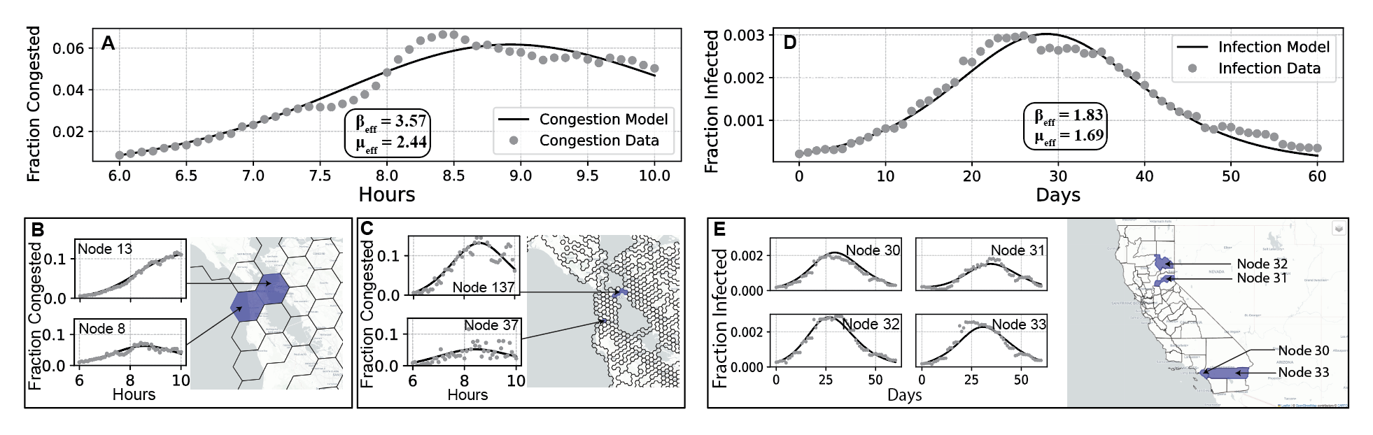
Model fits for different scales for the congestion model and the infection model. (A-C) Model fit for the whole region for the congestion model with two additional scales. (D-E) Model fit for the whole region for the infection model with one additional scale.
Constructing the networks
Traffic congestion empirically propagates on road networks. While streets can be modeled as a network where nodes are intersections and edges are roads, a higher level of aggregation is needed to capture the spreading dynamics at more actionable scales. Below, figure A shows one such spatial scale of aggregation, where different regions are depicted as polygons, and edges connect adjacent polygons that have a road criss-crossing across one of the shared boundaries (colored in red). On the other hand, figure B shows the network for the infection model for the state of California with counties as nodes, and trips between counties as edges.
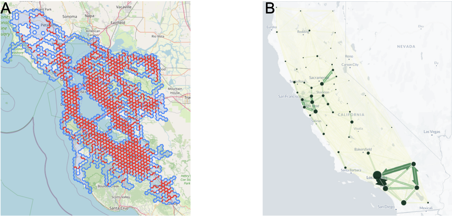
(A) Spatial network for the congestion model with polygons as nodes, and edges connecting adjacent polygons that have a road criss-crossing across one of the shared boundaries. (B) Network for the infection model with counties as nodes, and trips between counties as edges.
Hierarchical modeling framework
The hierarchical model captures how spreading dynamics evolve across different spatial scales. First, the network is determined at the finest spatial scale, and then recursively aggregated to coarser spatial scales (as indicated by the green arrows in the figure below). Then, the model (in this case, the SIR model) is fitted based on the aggregated data at the coarsest scale. The parameters thus obtained at the coarsest scale are used to inform the model fitting process recursively for the finer scales (as indicated by the red arrows in the figure below).
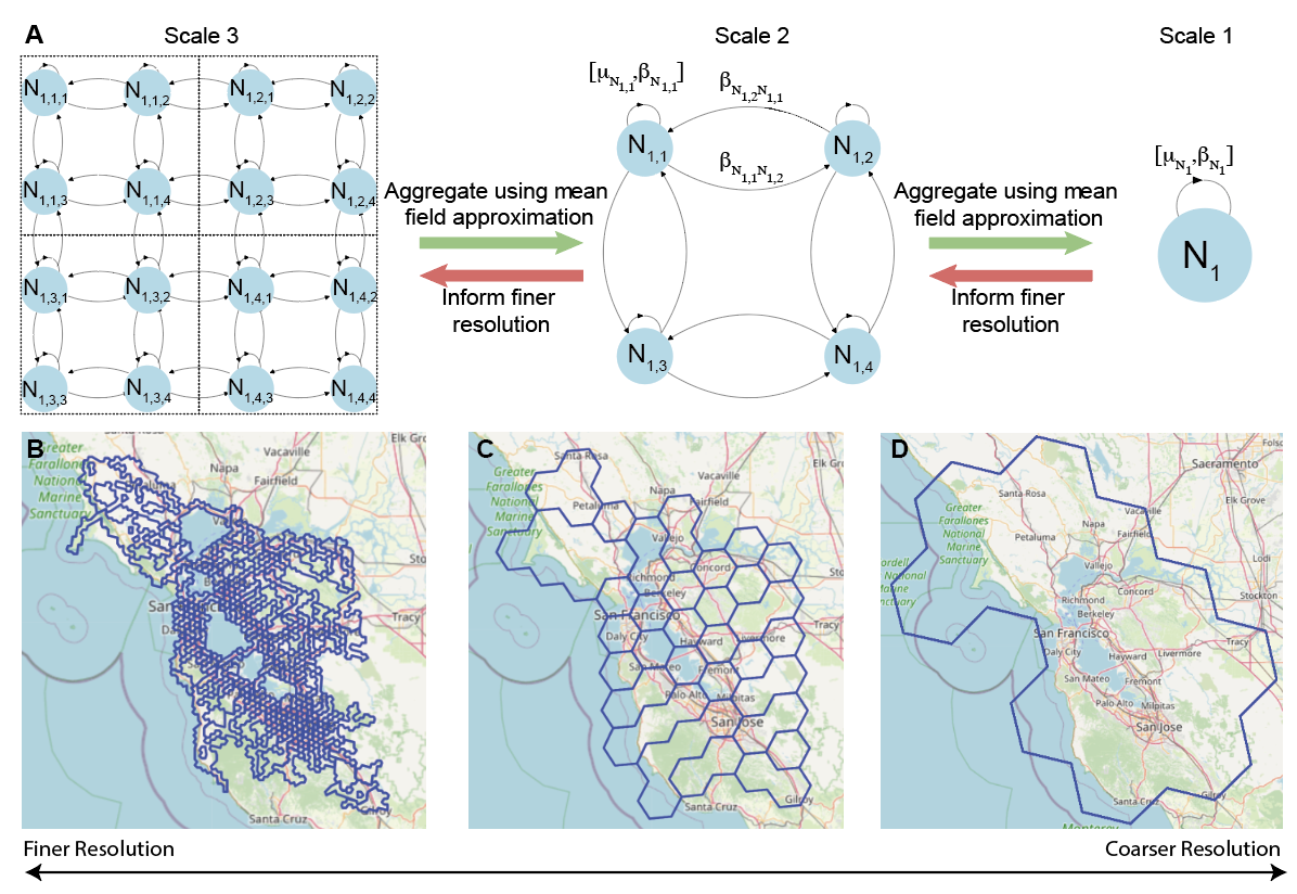
(A) Conceptual illustration of three hierarchical scales. (B-D) Three spatial scales across which traffic congestion spreading is modeled with network connectivity governed by connecting road links.
What next?
The simplicity of such models such as the SIR model allows for a higher degree of analytical interpretability, and thus with the development of more actionable strategies. We hope this work motivates further development of simple yet powerful models for understanding modern complex sociotechnical systems.